International Journal of Environmental Pollution and Remediation (IJEPR)
ISSN: 1929-2732

Volume 10 - Year 2022 - Pages 19-26
DOI: 10.11159/ijepr.2022.003
Impact of a low-income informal settlement in a headwater area at high-risk of erosion in Brazil
Maria Thereza Fonseca 1, Renan Lima2, Samuel L. L. Silva2, Hugo Luiz M. de Paula2, H Jonatas Ferreira da Cruz2, Jonatas Ferreira da Cruz2, Arthur Antão2, Juni Cordeiro3, Luiz Alberto I. Saenz3, Maria Rita Scotti 1,2
1
Architecture School and Graduate Program in Built Environment and Sustainable Heritage, Federal University of Minas Gerais, Brazil.
Antonio Carlos Avenue, 6627, Pampulha, Belo Horizonte, Brazil.
mariathereza@ufmg.br;
2Departament of Botany, ICB, Federal University of Minas Gerais, Brazil.
Antonio Carlos Avenue, 6627, Pampulha, Belo Horizonte, Brazil.
3Departament of Hydraulic Engineering and Water Resources, Federal University of Minas Gerais, Brazil.
Antonio Carlos Avenue, 6627, Pampulha, Belo Horizonte, Brazil.University, Department of Some Field
Abstract - The largest remaining area of preserved Atlantic Forest in the Belo Horizonte City (Minas Gerais, Brazil) protects many headwaters and watercourses. Among them, the Macacos stream is considered the most preserved with high water quality. However, since 2013 this region has suffered an intense and disorderly of informal settlement process by low-income communities, which resulted in a progressive loss of the original vegetation. Due to the lack of vegetation, this area became prone to erosional process as demonstrated by the topographic analysis. The Normalized Difference Vegetation Index (NDVI) demonstrated the great impact of the settlement process over the vegetation, ranging from 1 to 0. Besides, this eroded area has faced the loss of biodiversity as estimated by the richness and Shenon’s index as well as the invasion by exotic species as Brachiaria sp and Typha domingensis. Also, the erosional process in this hilly site resulted in the accumulation of high level of sediments in the Macacos stream. Therefore, the restoration of headwaters and riparian sites aiming at soil stabilization and vegetation restoration is highly recommended.
Keywords: Headwaters; Recharge water; Atlantic Forest; Restoration.
© Copyright 2022 Authors - This is an Open Access article published under the Creative Commons Attribution License terms. Unrestricted use, distribution, and reproduction in any medium are permitted, provided the original work is properly cited.
Date Received: 2022-08-31
Date Accepted: 2022-09-10
Date Published: 2022-09-15
1. Introduction
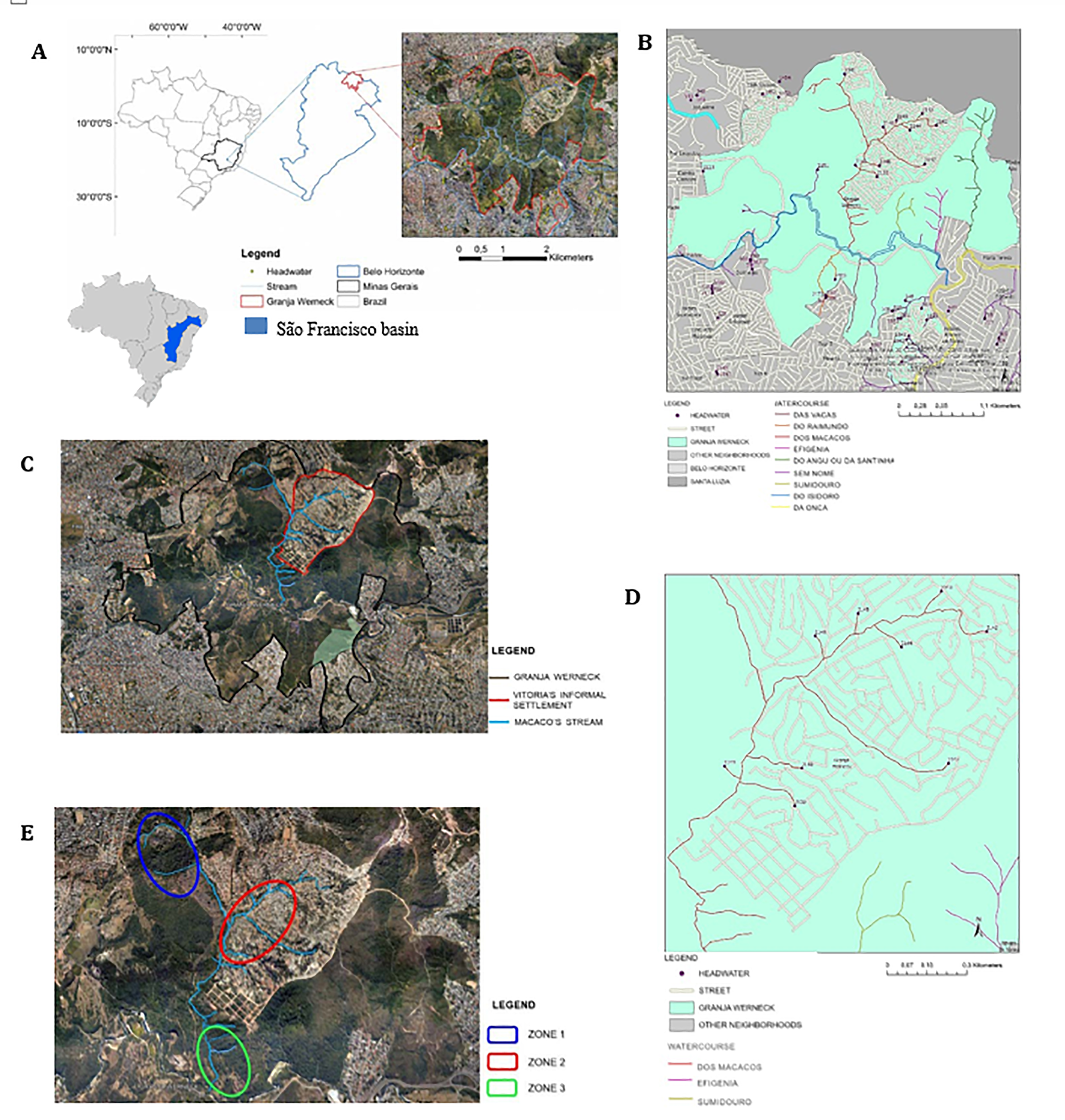
The largest preserved area belonging to the Atlantic Forest biome in Belo Horizonte City (Figure 1A) (19°48'53.58"S, 43°54'52.09"W) is located at the Izidora micro-basin of the São Francisco River basin (Minas Gerais, Brazil) and comprises 950 hectares, which corresponds to three times the area of the Central Park in New York City (341hectares). This site hosts around 280 headwaters and forms 64 streams (Figure 1B), being the Macacos stream (2,6 km²) the most preserved in terms of water quality, discharge and riparian forest preservation and extent [1]. However, this site has been suffering an intense process of informal settlement by low-income populations, resulting in the deforestation and degradation of this region. The Victoria informal settlement (Figure 1C) is currently inhabited by 4.500 families [2], which has disorderly occupied a top- mountain area, where several headwaters co-exist (Figure 1D). Consequently, this site has become prone to erosional processes associated with the loss of vegetation and water. In addition, the disorderly urbanization process has produced land fragility and instability, particularly because the houses and urban constructions have been built over some headwaters and along stream subjected to flooding events. Therefore, this has produced some urban pathologies related to damages to the houses such as infiltrations and wall cracks, resulting in a poorer life quality for this low-income community.
When there occurs an important land degradation with the complete loss of the environment resilience, the ultimate result is the soil destabilization and increase of erosional process [3]. The literature shows that the stabilization of superficial erosion, especially in slope areas, may be achieved by using an appropriate vegetation composition, particularly regarding the plant root system [4] though both hydrological and mechanical mechanisms [5]. Vegetation promotes the soil aggregation and porosity assuring the soil water infiltration and has a pivotal role in soil water content via evapotranspiration. Also, vegetation promotes the mechanical stabilization, able to encore the soil via the root’s system.
Therefore, the present study aims to evaluate the impact of the urban Victoria’s informal settlement over the land, vegetation, biodiversity and its consequences to the hydrological cycle. This study will hopefully subsidize the urban rehabilitation strategies for this area.
2. Material and Methods
2.1 Study Site
The study site is located in the north region of the city of Belo Horizonte in the São Francisco’s basin (Fig. 1A). This area has been suffering an impact of the disorderly urban informal settlement process, with loss of vegetation and threatening the stability of the soil in the region.
2.2 Experimental design for environmental impact analysis
2.2.1 Topographic analysis
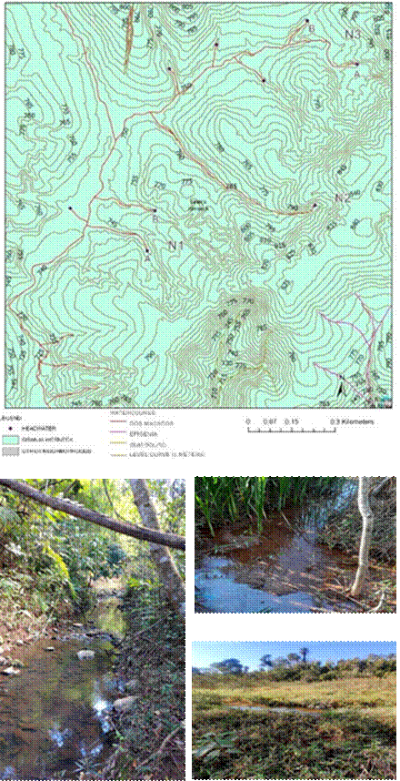
The study site is an informal settlement area where 4.500 families live over several headwaters and watercourses. Aiming at studying the erosional potential in this area, it was performed a topographic map which contains the level curves. The distance between the curves represents 5 meters of inclination. The data was based on the BH MAPS website (https://bhmap.pbh.gov.br/) provided by the City Hall of Belo Horizonte. The date was run using the ArcGis Pro software.
2.2.2 Vegetation studies: Normalized Difference Vegetation Index (NDVI) Analysis
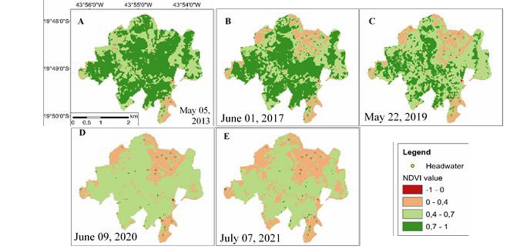
The extent of the impact of Vitoria’s informal settlement on vegetation cover and water bodies was calculated by the Normalized Difference Vegetation Index (NDVI), after atmospheric correction, based on images obtained from the Landsat 8/OLI satellite on the USGS website (https://earthexplorer.usgs.gov/), processed by ArcGis software. For this, satellite images obtained from May 2013 to July 2021 were assessed. NDVI is a sensitive indicator used for the remote sensing of green vegetation and it ranges from -1 to +1; and the higher values indicate the presence of photosynthetically active, green vegetation [6]. NDVI consists of determining a ratio of the difference and sum between the reflectance at less absorbing bands in the near-infrared (ρNIR) and the highly absorbing band in the visible red (ρred) [7]:

where:
NIR = spectral reflectance of the surface in the near-infrared range (band 5 of the Operational Terra Imager sensor - OLI/Landsat 8);
RED = spectral reflectance of the surface in the red band (band 4 of the OLI/Landsat 8 sensor).
2.2.3. Floristic assessment and biodiversity analysis
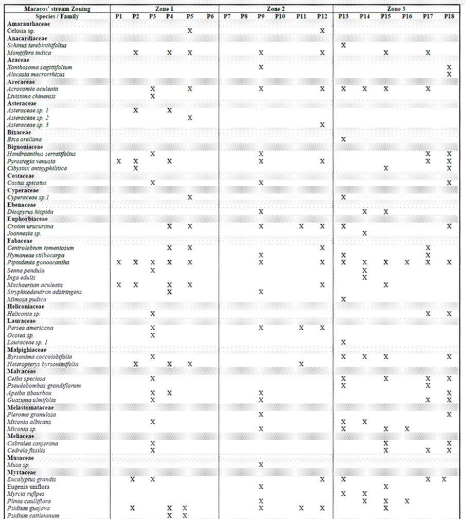
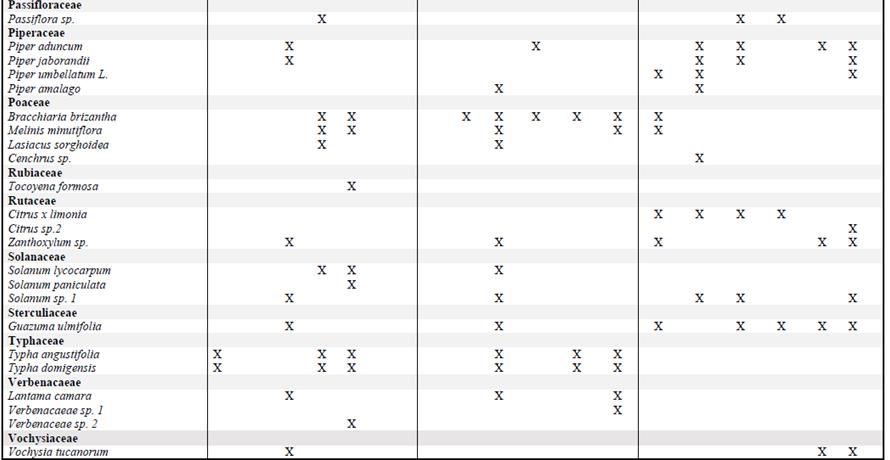
For the floristic analysis, the area was divided into three zones (Fig. 1E) alongside the Macaco stream. The blue zone is characterized by the portion that comprised the majority of the headwaters of the basin but is still subjected to some impact from the urban settlement (Fig. 1E). Zone two (red) refers to the stream fragment along the Vitoria’s settlement that is most impacted by the Vitoria’s informal settlement. Zone three (green) is the stretch of the Macaco stream which corresponds to a preserved area of Atlantic Forest. The experimental design was composed by three blocks corresponded the three zones mentioned above. Each block was divided in three transects of 30 meters where the plants were sampled. In each transect, it was sampled 3 plots of 5m² per plot totalizing 27 samples. All vascular plants, including both in the flowering stage and in the vegetative stage, found inside the plots were sampled according to Braun-Blanquet (1979) [8]. The specimens collected were herborized and deposited at the BHCB herbarium after taxonomic identification.
Species richness (number of species) was assessed as well as the Shannon-weaver biodiversity index using the following equation:
Where:
H’ = Shanon-Weaver diversity index;
pi = Proportion of individuals of i-th species in a whole community: pi= n/N, where
n= individuals of a given type/species and N= total number of individuals in a community;
∑= Sum symbol; and ln= Napierian logarithm. The results were analysed using one-way ANOVA (p ≤ 0.05) and the means was compared using Tukey's test at significative level of p ≤ 5%.
3. Results and Discussion
The figure 2A shows that the Vitoria’s informal settlement was established on an area at high risk of water erosion, originally composed of several headwaters where the vegetation was completely lost. The altitude difference from 725 to 840 revealed the erosive potential of this area considering the inclination as well as the presence of headwater and streams across the area. Surface water runoff is intensified during rainy season allowing the movement of sediments, further accelerating the erosive process.
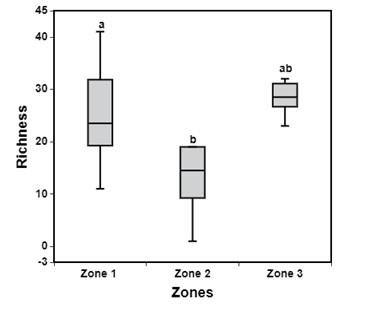
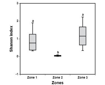
Although the Macacos stream may be considered still preserved at the zones 1 and 3 (figure 2B), the Victoria urbanization has impacted the streams with high level of sediments in zone 2 (figure 1E), leading to the massive invasion by exotic species such as Brachiaria sp and Typha domingensis (figure 2 D). The satellite images captured until 2013 (figure 3A) shows that the land was preserved with a NDVI index around 1. However, after 2013, there occurred a progressive and accelerated loss of vegetation from 2017 to 2019 with a NDV1 index of 0.4 (figures 3B e 3C). In the last two years (2020 and 2021), the NDVI index drop dramatically, revealing a severe loss of vegetation cover and a serious threat to the several headwaters (figures 3D and E). Such vegetation loss was particularly accentuated after 2017 as shown by the NDVI indices, as a consequence of the rapid, intense and disorderly process of urbanization of this area. However, the region surrounding the Victoria urbanization has also suffered an impact on its vegetation structure, especially after 2019 (figure 3C), which was attributed to the large contribution of sediments (figure 2B) from the collapsing erosions.
Indeed, the Table 1 shows a strong change in the plant species composition that occurred along the stream fragment along the Victorias’s informal settlement. This silting impact favoured the invasion by invasive and pioneer species in detriment of woody species from the Atlantic Forest. The impact of sediment over the stream can be evaluated by the significative loss of plant biodiversity (Shannon index) and richness (Fig. 4 A and B). These results showed that zone 1 and 3 presented a higher preservation degree than zone 2 where it was found the dominance of invasive species. Cordeiro et al. 2021 observed also the worsening of NDVI index after Fundão dam disaster what was followed by increase of invasive and pioneer species such as Brachiaria sp and Ricinus communis [9].
Riparian forests (RF) are transition zones between aquatic and terrestrial environments [10]. It is well known that woody species play a key role as floodplain buffer systems [11]. Riparian forest stabilizes stream banks; reduces erosion [11]; and intercepts surface runoff, and subsurface and deeper groundwater flows, buffering the effects of sediments, nutrients and organic carbon [10], [12]. Besides the woody species and its roots has the pivotal role in soil stabilization [13] through soil aggregation [14]. The soil aggregates formation depends on the organic matter decomposition and humic substances production [15]. Therefore, the riparian forest restoration is a priority effort for both the soil and houses stabilization, as well as erosion control in the Victoria’s settlement.
 A
A
 B
B
Table 1. List of Plant Families/Species and Occurrence in the Riparian Forest of Macacos Stream
4. Conclusion
The main impact caused by the disorderly urban Victoria’s settlement in an area where several headwaters and streams co-exist is the high degree of the erosional process with the accumulation of sediments in the streams and the progressive and significant loss of vegetation as estimated by the NDVI index. This process favoured the land invasion by exotic species in the riparian areas and headwaters. Besides, the increase of sediment in the streams determined changes in the vegetation composition in Victoria’s settlement area, resulting in a significant loss of plant richness and biodiversity of native Atlantic Forest species. Therefore, for the erosion control, soil stabilization and headwaters preservation, it is highly recommended the restoration of riparian forests and headwaters in this area.
Acknowledgements
This work was supported by Caixa Econômica Federal, RMPC Meio Ambiente Sustentável and the Graduate Program in Built Environment and Sustainable Heritage of the Federal University of Minas Gerais, Brazil.
References
[1] SUDECAP. Standard Procedure for Hiring and Preparing Infrastructure Projects. Belo Horizonte: SMEU Norms and Standards Management. 2018. 115 p.
[2] Rodrigues, G. A. B. L. “O caso Izidora: as ocupações urbanas e a reprodução do espaço em Belo Horizonte”. Mester dissertation, Architecture School, Federal University of Minas Gerais, Belo Horizonte, BR.
[3] King G., Hobbs R.J. “Identifying linkages among conceptual models of ecosystem degradation and restoration: towards an integrative framework.” Restoration Ecology, 2006, vol.14:pp. 369–378. View Article
[4] Reubens B., Poesen J., Danjon F., Geudens G., Muys B. (2007): “The role of fine and coarse roots in shallow slope stability and soil erosion control with a focus on root system architecture: a review’ in Trees, 2007, 21, pp. 385–402.https://doi.org/10.1111/j.1526-100X.2006.00145.x View Article
[5] Nilaweera N., Nutalaya P. “Role of tree roots in slope stabilisation” in Bulletin of Engineering Geology and the Environment, 1999, vol. 57 pp. 337–342. View Article
[6] Kaufmann, K., Zhou, L.-M., Myneni, R. B., Tucker, C. J., Slayback, D., Shabanov, N. V., & Pinzon, J. “The effect of vegetation on surface temperature: A statistical analysis of NDVI and climate data” in Geophysical Research Letters, 2003, vol. 30, pp. 21–47 View Article
[7] Rouse, J. W., Jr., Haas, R. H., Schell, J. A., & Deering, D. W. “Monitoring vegetation systems in the Great Plains with ERTS” in Proceedings of the third earth resources technology Satellite-1 symposium Washington, DC: National Aeronautics and Space Administration, 1973, pp. 10–14.
[8] Braun-Blanquet, J., Fitosociologia: bases para el estúdio de las comunidades vegetales. Madrid, 3. ed.: Aum. Blume; 1979.
[9] Cordeiro, J., Gomes, A. R., Santos, C. H. B., Rigobelo, E. C., Baptista, M. B., Moura, P. M., & Scotti, M. R. “Rehabilitation of the Doce River Basin after the Fundão dam collapse: What has been done, what can be done and what should be done?” in River Research and Applications, 2021, pp.1–15. [Online] Available: https://doi.org/10.1002/rra.3894 View Article
[10] Lowrance, R., Altier, L.S., Newbold, J.D., Schnabel, R.R., Groffman, P.M., Denver, J.M., Correll, D.D.L., Gilliam, J.W., Robinson, J.L., 1997. “Water quality functions of riparian forest buffers in chesapeake bay watersheds” in Environmental Management, 1997, vol. 21, pp. 687–712. View Article
[11] Naiman, R.J., Decamps, H., “The ecology of interfaces: riparian zones.” in Rev. Ecol. Syst, 1997, Vol. 28, pp. 621–658 [Online] Available: http://dx.doi.org/10.1146/annurev.ecolsys.28.1. View Article
[12] Anbumozhi, V., Radhakrishnan, J., Yamaji, E., “Impact of riparian buffer zones on water quality and associated management considerations” in Ecological Engineering. 2005, vol. 24, pp. 517–523 [Online] Available: http://dx.doi.org/10.1016/j.ecoleng.2004.01.007. View Article
[13] Bronick, J., Lal, R., “Soil structure and management: a review” in Geoderma, vol. 124, pp. 3–22, [Online] Available: http://dx.doi.org/10.1016/j.geoderma.2004.03.005. View Article
[14] Kimura A. C, Baptista M. B, Scotti M. R. “Soil humic acid and aggregation as restoration indicators of a seasonally flooded riparian forest under buffer zone system” Ecological Engineering, 2017. vol. 98, 146–156. View Article
[15] Duiker, W., Rhoton, F.E., Torrent, J., Smeck, N.E., Lal, R., “Iron (hydroxide) crystallinity effects on soil aggregation”. Soil Science Society of America Journal, 2003, vol. 67, pp. 606–611 [Online] Available: http:// dx.doi.org/10.2136/sssaj2003.606 View Article